
File:Tuhala Witches Well1-21-03-2013.jpg
Size of this preview: 800 × 533 pixels. Other resolutions: 320 × 213 pixels | 640 × 427 pixels | 1,024 × 683 pixels | 1,280 × 853 pixels | 2,560 × 1,707 pixels | 5,100 × 3,400 pixels.
Original file (5,100 × 3,400 pixels, file size: 9.62 MB, MIME type: image/jpeg)
Summary
| Description |
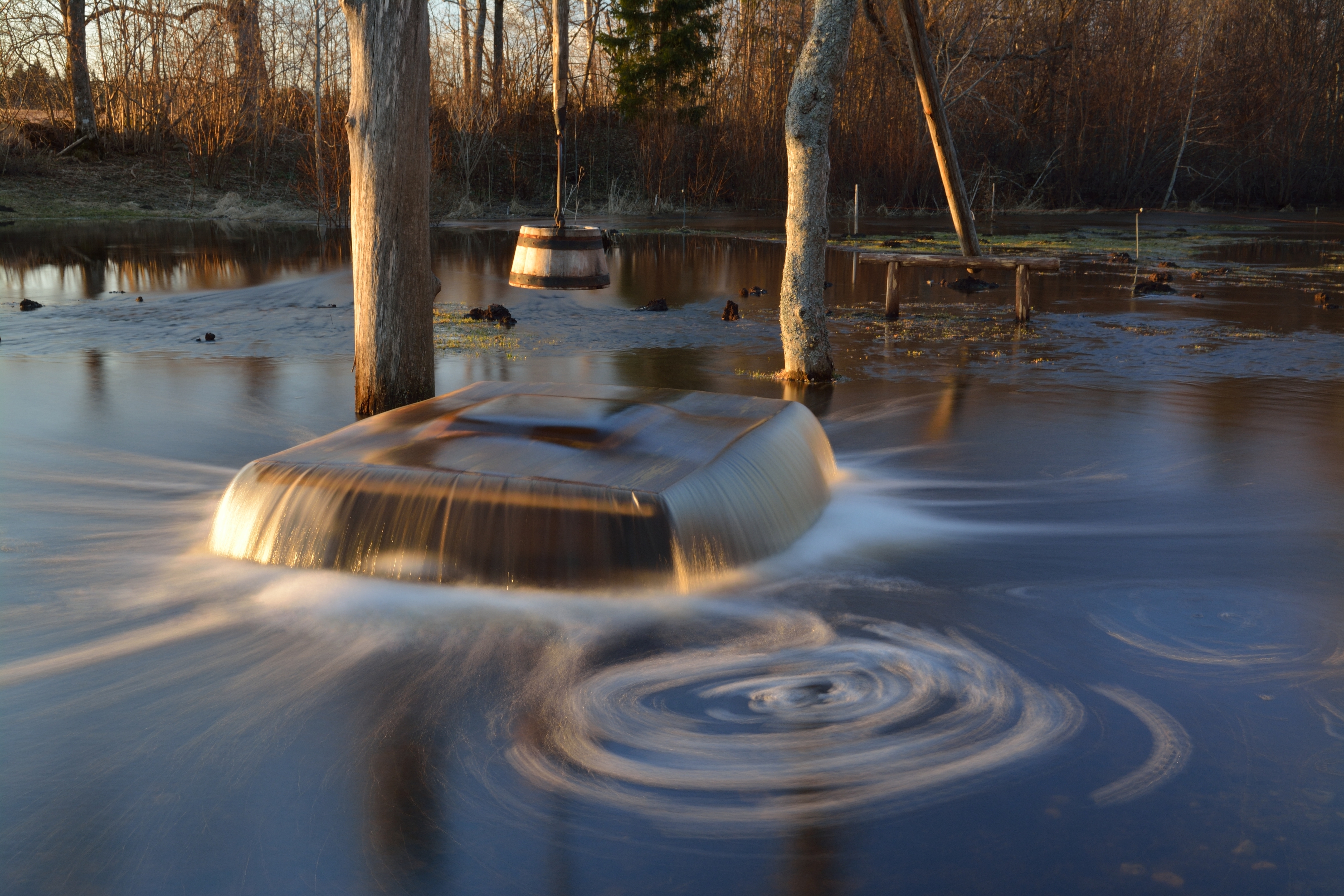
Eesti: Tuhala nõiakaev "keemas". Kaev on ajutine karstiallikas Tuhala maastikukaitsealal Tuhala karstiala läbival maa-alusel jõel.
English: Witch's Well (karst spring) in Tuhala (Estonia) is "boiling over". Water erupts for only a short period of time and not every year. It starts to come out from the well when excess water from the Mahtra swamp fills up the underground river and the overflowing river water seeks an escape through the well. According to local legend, the well boils over when the witches of Tuhala make a sauna below the ground and beat each other with birch branches, causing a commotion on the surface.
Deutsch: "Hexenbrunnen von Tuhala" (Estland). Wasser bricht aus dem Karstquelle nur für einen kurzen Zeitraum und nicht jedes Jahr. Nach heftigem Regen oder während der Schneeschmelze kommt es (meist im Frühling) zu einem Naturschauspiel: bei starkem Anschwellen des Flusses Tuhala, der hier unterirdisch verläuft, treten bis zu 100 Liter Wasser pro Sekunde aus dem Brunnen heraus.
Français : Le puits aux sorcières de Tuhala (Estonie) « déborde ». Ce puits, construit en 1639 et profond de seulement 2,35 mètres, est situé au-dessus d'un karst. L'eau peut y jaillir pendant quelques jours mais pas à chaque année ; elle commence à sortir du puits lorsque l'excès d'eau du marais Mahtra fait déborder une rivière souterraine et qu'une partie de cette eau déborde à travers ce puits, qui n'est que 4 à 9 mètres plus haut. Une légende locale raconte que les « bouillonnements » du puits sont provoqués par les sorcières de Tuhala lorsqu'elles prennent un sauna sous la terre et se flagellent mutuellement avec des branches de bouleau.
Polski: „Kipiące” wywierzysko o nazwie Studnia Czarownicy (Witch's Well) we wsi Tuhala w Estonii. Erupcje wody trwają krótko i nie każdego roku. Woda zaczyna wylewać się ze studni wtedy, gdy nadmiar wody z bagna Mahtra wypełni podziemną rzekę i jej wezbrane wody szukają ujścia przez studnię. Natomiast według lokalnej legendy studnia „kipi” wtedy, gdy czarownice z Tuhala zażywają pod ziemią sauny i smagając się brzozowymi gałązkami powodują zamieszanie na powierzchni.
Русский: "Вскипающий" Ведьмин колодец в Тухала (Эстония). Это явление происходит во время весеннего половодья, когда расход воды через подземную реку Тухала резко возрастает и она затапливает карстовые полости, над которыми находится колодец. Уровень воды в колодце поднимается, и происходит самоизлив. Согласно преданию "Ведьмин колодец" закипает, когда тухалаские ведьмы в нем парятся. |
| Date | |
| Source | Own work |
| Author | Ivar Leidus |
| Other versions |
 |
| Camera location | | View this and other nearby images on: OpenStreetMap |
|---|
Assessment
|

This image was selected as picture of the day on Wikimedia Commons for 7 August 2013. It was captioned as follows: Other languages:
Eesti: Tuhala nõiakaev "keemas" 2013. aastal. Magyar: A Boszorkányok kútja nevű karsztforrás˙(Észtország, Tuhala) 中文: 爱沙尼亚图哈拉的喀斯特温泉。 |
Licensing
I, the copyright holder of this work, hereby publish it under the following license:
This file is licensed under the Creative Commons Attribution-ShareAlike 3.0 Estonia license.
- You are free:
- to share – to copy, distribute and transmit the work
- to remix – to adapt the work
- Under the following conditions:
- attribution – You must give appropriate credit, provide a link to the license, and indicate if changes were made. You may do so in any reasonable manner, but not in any way that suggests the licensor endorses you or your use.
- share alike – If you remix, transform, or build upon the material, you must distribute your contributions under the same or compatible license as the original.

File history
Click on a date/time to view the file as it appeared at that time.
| Date/Time | Thumbnail | Dimensions | User | Comment | |
|---|---|---|---|---|---|
| current | 19:54, 21 April 2013 | | 5,100 × 3,400 (9.62 MB) | wikimediacommons>Iifar | User created page with UploadWizard |
File usage
The following pages on the English Wikipedia link to this file (pages on other projects are not listed):