
File:Location Large Hadron Collider.PNG
No higher resolution available.
Location_Large_Hadron_Collider.PNG (518 × 518 pixels, file size: 203 KB, MIME type: image/png)
| Description |
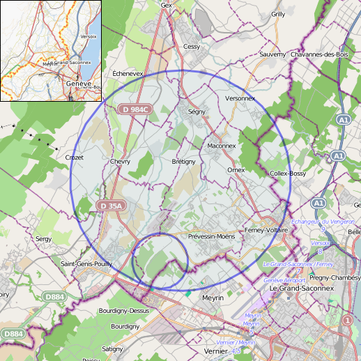
English: Location map of en:Large Hadron Collider (way #310046324) and en:Super Proton Synchrotron (way #66473762; blue circles) |
|||||||||
| Date | (see file history) | |||||||||
| Source | You may find a page on the OpenStreetMap wiki page for CERN | |||||||||
| Creator |
OpenStreetMap contributors |
|||||||||
| Permission (Reusing this file) |
OpenStreetMap data is available under the Open Database License (details). Map tiles are licensed under the Creative Commons Attribution-ShareAlike 2.0 license (CC-BY-SA 2.0).
This file is licensed under the Creative Commons Attribution-Share Alike 2.0 Generic license.
|
|||||||||
| Geotemporal data | ||||||||||
| Bounding box |
|
|||||||||
| Georeferencing | If inappropriate please set warp_status = skip to hide. | |||||||||
| Other versions | ||||||||||
Produced from en:OpenStreetMap:
- Map background: http://www.openstreetmap.org/?lat=46.2727&lon=6.0659&zoom=12&layers=M
- Map with LHC: http://www.openstreetmap.org/way/310046324#map=12/46.2727/6.0660
- Map with SPS: http://www.openstreetmap.org/way/66473762#map=12/46.2727/6.0659
- Overview map: http://www.openstreetmap.org/?lat=46.2727&lon=6.0659&zoom=11&layers=O
Final image created with en:GIMP
This file is licensed under the Creative Commons Attribution-Share Alike 2.0 Generic license.
- You are free:
- to share – to copy, distribute and transmit the work
- to remix – to adapt the work
- Under the following conditions:
- attribution – You must give appropriate credit, provide a link to the license, and indicate if changes were made. You may do so in any reasonable manner, but not in any way that suggests the licensor endorses you or your use.
- share alike – If you remix, transform, or build upon the material, you must distribute your contributions under the same or compatible license as the original.
File history
Click on a date/time to view the file as it appeared at that time.
| Date/Time | Thumbnail | Dimensions | User | Comment | |
|---|---|---|---|---|---|
| current | 17:13, 11 November 2014 | | 518 × 518 (203 KB) | wikimediacommons>RokerHRO | optipng -o7 → 45.07% decrease |
File usage
The following pages on the English Wikipedia link to this file (pages on other projects are not listed):
Global file usage
The following other wikis use this file:
- Usage on simple.wikipedia.beta.wmflabs.org