
File:Kyiv after Russian shelling, 2022-10-10 (073).webp

Size of this PNG preview of this WEBP file: 800 × 533 pixels. Other resolutions: 320 × 213 pixels | 640 × 427 pixels | 1,024 × 683 pixels | 1,280 × 853 pixels | 2,048 × 1,365 pixels.
Original file (2,048 × 1,365 pixels, file size: 394 KB, MIME type: image/webp)
.webp)
Summary
| Description |
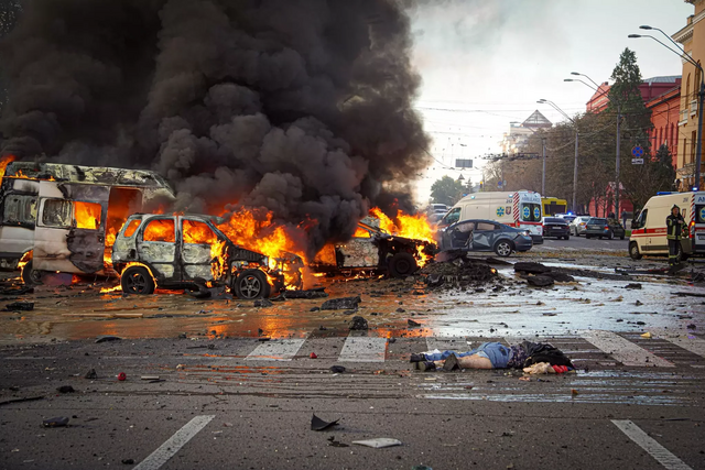
Русский: Киев после российских ракетных ударов 10 октября 2022 года. Перекрёсток Владимирской улицы и бульвара Тараса Шевченко.
English: Kyiv after Russian missile strikes on 10 October 2022. Intersection of Volodymyrska Street and Taras Shevchenko Boulevard.
Українська: Київ після російського ракетного обстрілу 10 жовтня 2022 року. Перехрестя Володимирської вулиці та бульвара Тараса Шевченка. |
| Date | |
| Source | source page |
| Author | Main Directorate of the State Emergency Service of Ukraine in Kyiv |
| Object location | | View this and other nearby images on: OpenStreetMap |
|---|
.webp¶ms=050.443600_N_0030.512300_E_globe:Earth_class:object_type:object__&language=en)
Licensing
 |
This file comes from the website of the Main Directorate of the State Emergency Service in Kyiv and is licensed under the Creative Commons Attribution 4.0 International License.
In short: you are free to distribute and modify the file as long as you attribute kyiv.dsns.gov.ua.
|
This file is licensed under the Creative Commons Attribution 4.0 International license.
- You are free:
- to share – to copy, distribute and transmit the work
- to remix – to adapt the work
- Under the following conditions:
- attribution – You must give appropriate credit, provide a link to the license, and indicate if changes were made. You may do so in any reasonable manner, but not in any way that suggests the licensor endorses you or your use.
File history
Click on a date/time to view the file as it appeared at that time.
| Date/Time | Thumbnail | Dimensions | User | Comment | |
|---|---|---|---|---|---|
| current | 18:39, 5 August 2023 | | 2,048 × 1,365 (394 KB) | wikimediacommons>FMSky | rm watermark |
File usage
The following pages on the English Wikipedia link to this file (pages on other projects are not listed):
.webp)