
File:Map of war in Yugoslavia, 1992.png
Size of this preview: 800 × 527 pixels. Other resolutions: 320 × 211 pixels | 640 × 421 pixels | 1,024 × 674 pixels | 1,280 × 842 pixels | 1,887 × 1,242 pixels.
Original file (1,887 × 1,242 pixels, file size: 148 KB, MIME type: image/png)

|
This map image could be re-created using vector graphics as an SVG file. This has several advantages; see Commons:Media for cleanup for more information. If an SVG form of this image is available, please upload it and afterwards replace this template with
{{vector version available|new image name}}.
It is recommended to name the SVG file “Map of war in Yugoslavia, 1992.svg”—then the template Vector version available (or Vva) does not need the new image name parameter. |
Summary
| Description |
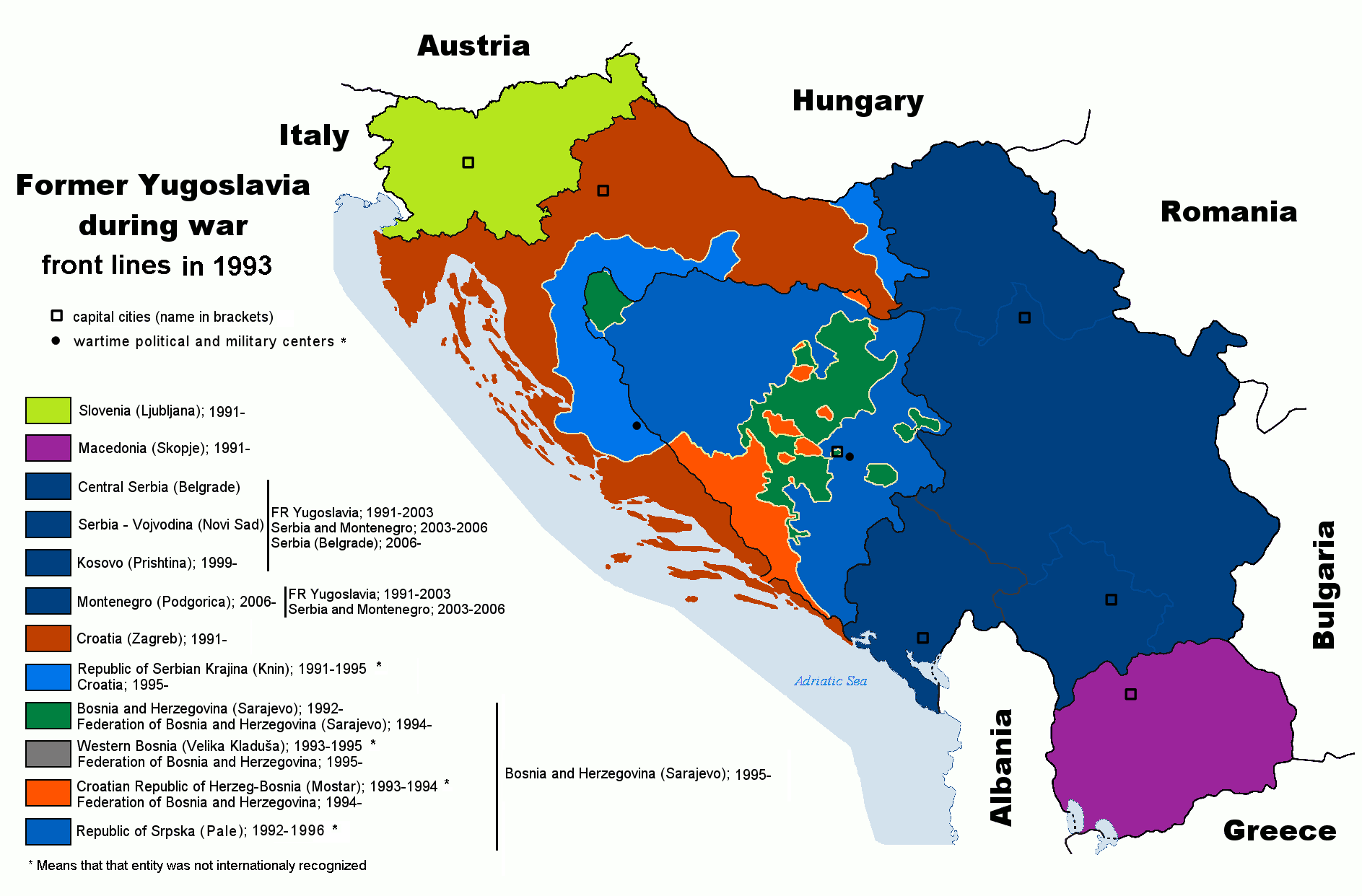
English: Map of former Yugoslavia during last wars. War political entities in Croatia and Bosnia-Herzegovia are marked. |
| Date | 6 September 2006 (original upload date); 21 July 2011 (last version) |
| Source | Transferred from en.wikipedia to Commons. |
| Author | Paweł Goleniowski (swPawel) |
| Other versions |
|


Licensing
I, the copyright holder of this work, hereby publish it under the following licenses:
| This file is licensed under the Creative Commons Attribution-Share Alike 3.0 Unported license. Subject to disclaimers. | ||
| ||
| This licensing tag was added to this file as part of the GFDL licensing update. |

|
Permission is granted to copy, distribute and/or modify this document under the terms of the GNU Free Documentation License, Version 1.2 or any later version published by the Free Software Foundation; with no Invariant Sections, no Front-Cover Texts, and no Back-Cover Texts. A copy of the license is included in the section entitled GNU Free Documentation License. Subject to disclaimers. |
This file is licensed under the Creative Commons Attribution 2.5 Generic license.
- You are free:
- to share – to copy, distribute and transmit the work
- to remix – to adapt the work
- Under the following conditions:
- attribution – You must give appropriate credit, provide a link to the license, and indicate if changes were made. You may do so in any reasonable manner, but not in any way that suggests the licensor endorses you or your use.
You may select the license of your choice.
Original upload log
The original description page was here. All following user names refer to en.wikipedia.
- 2011-07-21 10:53 DIREKTOR 1887×1242× (96002 bytes) Colors
- 2008-08-10 11:16 Ceha 1887×1242× (97124 bytes) Changed front lines around Bihać. see [http://en.wikipedia.org/wiki/Image:Western_Bosnia_1994.png]
- 2006-09-06 00:08 Ceha 1887×1242× (97673 bytes)
File history
Click on a date/time to view the file as it appeared at that time.
| Date/Time | Thumbnail | Dimensions | User | Comment | |
|---|---|---|---|---|---|
| current | 23:00, 25 March 2020 | | 1,887 × 1,242 (148 KB) | wikimediacommons>Santasa99 | one enclave added |
File usage
The following pages on the English Wikipedia link to this file (pages on other projects are not listed):